Welcome!


Monticello Road is a community arts project in Charlottesville, Virginia. Through photography and a series of public events and conversations, we explore how an art can be an essential, integral and everyday part of a healthy community.


About | Summary | Events | Media | Backers | Contact/Sign Up | Donate


Showing posts with label Urban landscape. Show all posts

Wednesday, October 18, 2017

Mobility and Mobilization


Like the Practicum project, this new venture will connect kids, families and communities to resources and opportunities.

I have started a new job with Piedmont Environmental Council. In cooperation with the Thomas Jefferson Planning District Commission and with support from the Charlottesville Area Community Foundation, we are working with communities in both Charlottesville and the urban areas of Albemarle County to envision and implement a connective network of trails and greenways. In many ways, it is an enlargement of the Monticello Connectivity practicum project.

The project has two main intertwined elements. We will talk to many people in diverse organizations and neighborhoods to develop a multi-modal transportation plan that truly reflects community ideas, needs and values. We will also engage with stakeholders to develop the civic infrastructure to keep sustain public advocacy to bring that vision to reality both by holding government accountable and by contributing their passion and even labor as well as their ideas. It’s about both mobility and mobilization.

We will begin our two-year project with a kickoff event on Wednesday, November 8 6-8 p.m. at the Jefferson School African American Heritage Center. Greenways guru Chuck Flink and Max Hepp-Buchannan from Bike-Walk RVA will share insights about the benefits of greenways and ideas about how to make them happen.

We will follow that with a series of events, community visits and conversations about how to make a more connected community.

Kickoff Event | Project Page

Tuesday, May 30, 2017

Saunders-Monticello Trail User Thoughts on Connectivity

The following two entries dive deep into the recent report I co-authored on connecting Charlottesville to Monticello & beyond.

A large part of our research centered around the fabulously-successful Saunders Monticello Trail, which serves as a gateway to Monticello and will the linchpin of our connector(s). We conducted a survey of current trail users because it is essential that we understand their preferences and desires if our own project is to be successful. The survey succeeded far beyond our expectations, with 1010 responses in 18 days.


The chart tallies a manual count of concept mentions relative to connectivity. We also did a word cloud cloud (see end of article) but we found the manual method much more informative and precise. A word cloud, for example, does not distinguish between a user who says "I want a connection," and one who says, "I don't want a connection." Word clouds give a useful glimpse but are not sound basis for policy.

Out of the 1,010 survey responses, there were 443 comments in response to the open-ended question “Do you have any other comments about connecting the trail to Charlottesville and/or other destinations (e.g. Morven Farm, Highland, Mill Creek, PVCC)?” The chart left illustrates the relative themes that emerged. All topics with two or greater mentions are included.

Endorsements
Among the responses, the most mentioned by far was a positive response expressing support and excitement for the trail.

Destinations
Respondents mentioned Piedmont Virginia Community College more than any other destination, but quickly followed by many of the major destinations explored in the study: Morven Farm, the Rivanna Trail, James Monroe’s Highland, Route 20, Belmont and the Charlottesville downtown area, and Avon extended and its associated neighborhoods (including Mill Creek). Several other respondents considered the broader regional connection possibilities, including the 3 Notch’d Trail, Scottsville, and Crozet.

Bikes and Accessibility
A significant number of respondents mentioned desire for bike access through the connection. Some respondents hoped for facilities if the trail is expanded and connected into a wider network, particularly parking. Regarding accessibility, several respondents mentioned a desire to continue bringing their family to the trail, others mentioned a desire to bring dogs, to connect the trail to transit, and for the trail to be ADA accessible and friendly for senior users. Of particular note about the transit access, several respondents mentioned a desire for a shuttle bus that would connect the end of the trail to key destinations within Charlottesville, including PVCC, UVA, and the Downtown Mall.

Trail Characteristics and Amenities
Several respondents mentioned a desire to highlight and maximize historic and cultural connections through the trail network expansion. Some respondents mentioned key physical aspects of the trail, including a preference for a pathway that is not directly adjacent to the street, and a desire to increase crosswalk safety.

A few respondents reacted negatively to the premise of the study: either they did not desire a trail, did not desire a trail to connect to their neighborhood, or did not desire bikes to be allowed to use the trail. Two respondents expressed concern and recommended thoughtful consideration about the people who have set up camps beneath and near the I-64 and Route 20 bridges.

Friday, April 28, 2017

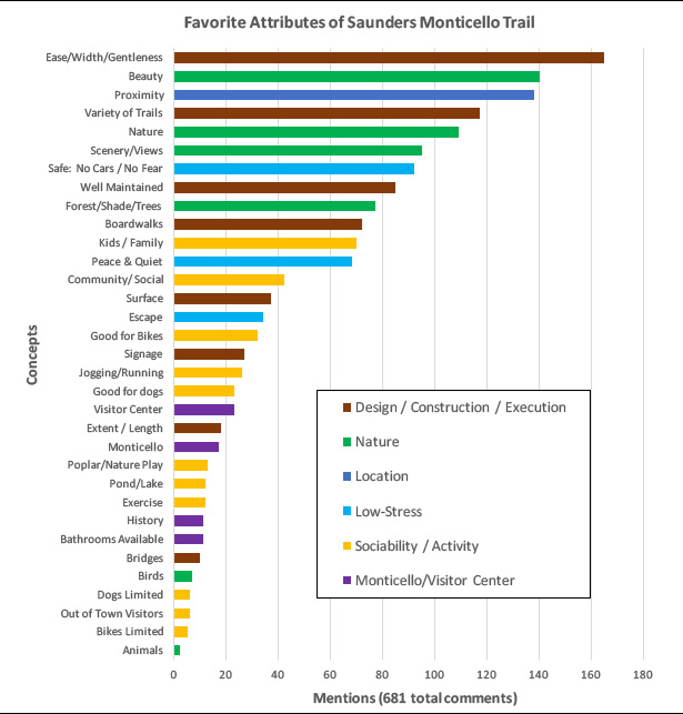
Why Visitors Love the Saunders Monticello Trail


saunders_thoughts.jpg

Out of the 1010 survey responses, there were 681 comments of various length. We divided the terms into categories, among which a few key themes emerged. They are summarized, in chart form, above. Here's what they tell us:

Design and Upkeep
The gentle, sloping boardwalks are wildly popular. Users like that they moderate the challenge of climbing a mountain and make the trails accessible to people of all abilities. They like that they’re wide enough to be social, that there are also more rugged options, there is educational signage along the way and they are long enough to merit a trip. The meticulous maintenance is a very significant contributor to the sense of welcome.

Nature
Visitors love the park’s natural beauty.

Proximity to Where they Live and Work
Exposure to nature in a way that is highly welcoming and close to home completes a triangle that explains the park’s success.

No Cars, No Fear, No Stress
The Saunders Trail is a stress-free environment. Some users talked about safety from cars, others about safety from crime. Most users just used the word “safe” and without context it is impossible to know which version of safety they were referring to. They also see the park as a place to get away from daily life. It would be interesting to follow up with research to know how much (and what kind of) contact with humanity is enough for perception of safety from crime. It is clear, however, that park users value the absence of cars, which is interesting given that the trail was built as part of a parkway project.

Kids, Families, Community and Activities
Even though the trail is a place of natural escape, users still value the social connections that happen there, whether they go with friends or meet acquaintances. The park is designed in such a way to promote positive interaction as well as harmony between active and contemplative uses.

Amenities at the David M. Rubenstein Visitor Center and Monticello Itself
It appears that most Saunders Trail users visit the park as a destination independent of Monticello. A small number did indicate appreciation for the connection to the World Heritage Site and the visitor center as a destination and amenity for the trail.

Implications for a Connector Trail
The overwhelming response to the survey indicates very high demand for a connector.

A large percentage of users are from Charlottesville, the others from urban parts of Albemarle, or from out of state. All of these users would benefit from a connection, and the majority have stated they would use it. Many would leave their cars at home, improving community fitness and reducing stress in the parking lot.

Users are interested in a widely connective network that is both kid- and bike-friendly. Accessibility by public transportation and for the elderly and disabled is important. Destinations near all of the corridors are mentioned, with enthusiasm roughly proportional to proximity. There is strong support for an extension to Highland and Morven, which is not one of the routes studied in this report, but is being addressed independently by Highland and Morven.

Amenities like bathrooms, water fountains, and quality signage are desirable. A fractional minority oppose the trail for fear that more users will spoil the Saunders-Monticello Trail experience, but far more indicated they expect an enlarged network would spread users and reduce crowding.

In order for the trail to be well integrated with the Saunders-Monticello Trail it will need to exhibit the following qualities:
  • Users should be fully separated from automobiles.
  • It should be wide enough to comfortably accommodate cyclists and groups of pedestrians.
  • Inclines should be as gentle as possible.
  • It should feel safe for women and the elderly.
  • There should be natural scenery.
  • There needs to be a sustainable maintenance plan.
  • I f cyclists and pedestrians use the same corridor, it needs to be well-managed either through signage, clear rules, or separate facilities.
  • Clear directional and even some interpretive signage would be welcome. 

This is an excerpt from the report Charlottesville to Monticello and Beyond. Read the executive summary and download the full report here.

Sunday, January 22, 2017

Monticello Connectivity Pre-Assessment:
Executive Summary


Saunders Bridge from Monticello (Aaron Eichorst via instagram)

This is the executive summary of a 50-page pre-assessment report I wrote about reconnecting Charlottesville to Monticello and beyond for pedestrians and cyclists. That document is the result of an independent a study course at the University of Virginia's Masters of Urban and Environmental Planning program. The next phase will be an in-depth practicum in which I will be joined by four other graduate students. We will delve with greater detail into the issues identified in this report. That will be available in the late spring/ early summer. -Peter Krebs

Monticello is an important source of Charlottesville’s history, cultural identity and economic vitality. In combination with the Academical Village at the University of Virginia it is a nearly unmatched resource and very unusual for a town of this size. Monticello is close to the city (its lands are less than a mile from the border) and it is visible from many locations, yet it is difficult to get there without a car. This discontinuity poses problems of equity and unrealized opportunity for Monticello, the city and the region.

Monticello was once easily accessible. There were multiple routes into town with significant travel and exchange in both directions. When Interstate 64 was built (in the 1960’s and 70’s) all of those routes were severed except for one (VA-20) and that was widened for highway speeds without accommodation for bicycles or pedestrians, effectively cutting Monticello off from those who do not have—or choose to use—a car.[1] There is no transit connection, which limits residents and visitors alike.

The Thomas Jefferson Foundation, which owns and operates Monticello and much of the surrounding lands, bridged half the distance in 2000 by opening Saunders Monticello Trail. This winding two-mile pathway is fully ADA accessible (while climbing a mountain!) and its beauty attracts tremendously diverse visitorship. Combined with the adjoining parkland, it is a wildly successful landscape and a destination in its own right yet it is difficult to get there with a vehicle and nearly impossible without one.

Saturday, October 8, 2016

Planning Profession Context and Logic Model for Monticello Road Extended

The following text is from a paper I wrote for my Independent Study Project on re-connecting Charlottesville to Monticello for pedestrians and cyclists.


Old Monticello Road will be one option the team will explore to reconnect Monticello to Charlottesville.

There are many different lenses through which planners view the practice and even more ways to attack difficult problems. This essay frames my Monticello Connectivity project within the discipline and finishes by considering my own role. In between I describe the logic model I use to chart a path from resources at hand to beneficial social outcomes.

Planning in the Public Interest

Peter Marcuse describes three major planning currents (and sub-currents) along a continuum of faith in—or deference to—institutional power. One could argue for many hours—and some people do just that—about the appropriate setting for that dial but it ultimately comes down to the planner’s sensibilities.

Within his formulation, this project would be described as Social Reform Planning or planning in the public interest. It works with existing institutions to make the world better for a broad majority of the population, while harming very few if anyone,1 as opposed to focusing primarily on either the maintenance of social order or the uplift of the oppressed.

My approach shades into Advocacy Planning because I believe that the institutional actors need to modify their approach. As I will eventually argue in my pre-assessment document,2 the project cannot happen without regional cooperation beyond what we typically see and the result cannot be just without a very inclusive process. Fortunately, the key stakeholders already agree on these principles: there is both a physical need and a need for process reform. This project will address both.

Tuesday, September 13, 2016

A Challenging Site with Potential


The site is at the SE corner of Monticello and Carlton Roads. (Charlottesville GIS)

The Belmont Carlton Neighborhood Association received a visit from Christopher Henry of Stony Point Design/Build. He was there to talk about an idea—still very much in the preliminary stage—of developing a small cluster of lots totaling about 2/3 acre at the corner of Carlton and Monticello Roads. This blog visited that site a few years ago on a backyard biophilia safari.

Before I go any further, I would like to praise Mr Henry for two things that, should it go forward, will make the project more likely to succeed with the Planning Commission as well as with its future neighbors.

First of all, he obviously read Charlottesville’s Comprehensive Plan and came up with a project that aligns with the City’s goals and values, particularly as respects diverse housing opportunities. Second, and most important, he’s talking early: meeting with planners and listening to the community BEFORE getting invested in a specific execution or set of plans.

Sunday, May 22, 2016

Moblizing by Moosifying


It was impossible to choose a best photo from this event but Ms Dogwood dunking the ex-mayor was typical. [more]

In case you ever needed another reason to go Moose’s Restaurant (and there were already plenty), they just did a super-cool fundraiser for the Shelter for Help in Emergency.

The fun unfolded in three parts. They kicked off on Friday (the 13th) with a doughnut eating contest. Saturday morning (the 14th) they had a block party that included music, dancing, a craft fair, a race car you could touch (and pose with) and—best of all—a dunk tank that was extremely busy. Saturday night was a concert at the Jefferson School. The fundraiser netted $3050 and lots of fun and community fellowship.

When I first visited Moose’s (then called Moore’s Creek) I was afraid to go inside 1) because they share a building with a gun shop and 2) because there were a million police cars parked outside. That seemed like a bad combination, but come to find out that the cruisers were there because it’s the best short-order restaurant in Charlottesville. They all stop there on their way into town or between shifts.

Monday, December 21, 2015

About that View...


Two photos from the same spot, taken three years apart. Left: "The Park, 2012." Right "Belmont Steps subdivision, 2015."

As part of my coursework in Urban and Environmental Planning at the University of Virginia, I am performing a series of GIS (Geographic Information System) analyses of the Monticello Road project. GIS provides empirical data to check (or underscore) what intuition tells us. This is the first of a three-part meta analysis. Next: Picture Distribution | To Come: Backer Distribution

Although it is not the main purpose, the Monticello Road project provides undeniable (and sometimes wrenching) evidence of the ways the neighborhood changes over time. The above pairing is especially jarring. We know that frequent low-dose exposure to Nature is beneficial to health and well-being. I suspect that the same can be said of Heritage as well so its loss is something we notice.

When one of my colleagues saw the above photo, he was surprised to hear that the Neighborhood Association did not oppose the subdivision. In fact, there was nothing for them to say about it because it was done by-right, meaning the land-owner did not need anyone's permission as long as they stayed within the zoning regulations, which they did. Additionally, we say all the time that we like in-fill development (instead of sprawl) and this is what it looks like.

So although this kind of change is inevitable and possibly beneficial, we should not pretend that there is no cost. We know there is, but it is not quantifiable, which is a real liability when we consider the pocket full of financial statistics a developer will present.

GIS allows quantitative viewshed analysis and I thought it would be interesting to look at the cumulative effect of building upon the the landscape and heritage vistas in the neighborhood.

For reference, I chose the peak of Mont Alto, so beautifully framed in the photo above left.

Thursday, September 17, 2015

Yard Dreams


Yard Dreams takes art out of the white box and into the streets—and yards—of Belmont. I will be one of fifteen 15 artists installing art in neighbors’ yards this for the weekend. The art will be on view 5 p.m. Friday to 5 p.m. Sunday, with a self-guided tour all weekend and a fun neighborhood potluck block party to celebrate the end of Summer on Saturday evening (3-9).

My piece, mending, tweaks two of my neighbors via perhaps the best-known poem in the American canon, Robert Frost’s Mending Wall. The two—both my friends—have a long list of grievances and have found that the best solution is not engage with one another at all. Sometimes that is the best idea, and it probably is in this case and a palisade fence now separates them.

Although the best-known phrase in the poem is “Good fences make good neighbors,” Frost clearly thinks otherwise and backs his claim by pointing out that Nature never allows a fence to stand for very long.

My piece, presented with the good-spirited cooperation of one of the neighbors in question, allows visitors to rearrange the words of that line to propose alternative approaches.

Interested in community engagement through the arts? This is what it looks like. Map, info at http://yarddreamspvcc.com/
Daily Progress Preview

Saturday, September 12, 2015

Unsorting America: an Encounter w Dr. Mindy Fullilove

Few issues are as vexing or worrisome as the accelerating process of social sorting that is un-knitting the American people. It’s everywhere—in our politics, school segregation (which has returned with a vengeance and in surprising ways) and in our settlement patterns, including otherwise progressive neighborhoods.

Its what I'm learning is a “wicked” problem—one that must be unraveled from many directions simultaneously while each effort affects the others. I was fortunate to hear Dr Mindy Thompson Fullilove speak on the issue, in which she laid the issue out in stark terms but also proposed a plausible path forward.

Sunday, June 14, 2015

Taking New Ideas to the Old School


I hope to bring the planning community some news ways of seeing communities and the people who live there.

I’m really excited to announce what many people already know: I will be joining the Master of Urban and Environmental Studies program at the University of Virginia this fall. It’s a two-year program. Meantime I will work the next marathon in a limited capacity, while concentrating primarily on my studies.

While I am there, I plan to focus improving the front end of the planning process through community discovery (which so often falls woefully short) through the arts and bringing a focus on improvements in well-being, which includes a host of under-appreciated aspects such as access to heritage, spiritual exploration, fresh air and exercise, healthy foods, opportunities for expression and engagement with neighbors.

These are topics familiar to readers of this blog. So it’s really the perfect extension of the work I’m doing. I’m going deeper by learning more, by contributing to a wider discussion with unique perspectives I’ve gathered and—not insignificantly—obtaining an accreditation that will help realize some of the ideas we’ve discussed together here.

Tuesday, January 13, 2015

The People of Monticello Road: Aimee Hunt


Aimee Hunt has lived on Monticello Road since 2007. An artist and educator, she works at the Fralin Museum of Art at the University of Virginia while also studying art education at Virginia Commonwealth. She enjoys, and is part of, the neighborhood’s creative community.

Aimee has made an intriguing contribution to the physical environment through an unconventional home renovation with results that somehow manage to be both subtle and audacious. I spoke with her about it over tea as her two children assembled her daughter’s 12th birthday cake.

I first learned about Aimee’s project when I was visiting her then-neighbors Dan and Serena a few years ago and noticed that her small cinder block home had a tarp where the roof should be. Because of the lot’s wedge shape, it did not make sense for Aimee to build back into it, so she built upward. That decision was in some ways made for her when she discovered structural issues that would have doomed the existing hat.

Tuesday, December 16, 2014

Architects Should Listen to their Mothers


This is a common problem where the old and new meet, but it doesn't need to be.

Charlottesville has been popping up in the New York Times a lot lately—and for mostly unfortunate reasons. The latest breakfast-table surprise was an op-ed piece about high-concept, tone-deaf architecture.

lament big-A Architecture’s willful disconnect with the public and used a specific case in our fair city as an example. While the whole thing is very well written (you should go read it now and come back) I thought it was great because it offers a solution right at the top—although not explicitly.

It opens with an exchange between an architect and his 88-year-old mother critiquing a house on Elliott Avenue, presumably the one pictured above. The mother thought it looked like a shipping container with some cheap scrap metal shoved against it and completely unconnected to its surroundings, which is true.

The problem isn’t that the layperson lacks understanding of the architects’ vocabulary, it’s the converse. Architects too often show little interest in the site’s heritage and none for the neighborhood vernacular, as if they're annoyances or threats to freedom. If architecture aspires to art or genius status, it must simultaneously sit in the past, present and future. It’s not enough to be bold or forward-looking unless you’re trying to do something that is completely irrelevant, disconnected from what’s on everyone else’s mind—the world of what was and/or is. Context matters.

Thursday, December 4, 2014

The Power of Weak Ties


There are many spaces along Monticello Road that are suitable for casual interactions.

I’ve just finished Richard Florida’s The Rise of the Creative Class and while I don't agree with everything he said one thing jumped out. About halfway through he offers a counterargument to Robert Putnam’s best-seller Bowling Alone. Putnam laments a loss of social capital in America as a result of less participation in civic and social groups like clubs and bowling leagues.

After arguing that it’s not even really happening—today’s kids are more likely, for example, to be in a soccer league than I was—Florida explores the possible benefits that come with shallow ties. That really got me thinking about my own project because I think it says a lot about why Monticello Road is such a great place.

Saturday, November 15, 2014

Running and Place: a Conversation with Allan Steinfeld


Courtesy NYRR

Allan Steinfeld is the former race director of the New York City Marathon and president of New York Road Runners. I am fortunate to say that he is also a mentor and a friend. I had an email conversation with him about the relationship between running and sense of place, a few days prior to his induction into the NYRR Hall of Fame and the Marathon’s 44th running.

Peter: To know a place you must get out of the car, but when most people say that they’re usually thinking of walkers. How does one’s perspective about a place [neighborhood, park, road, etc] change as a runner, as opposed to walking, riding a bike or driving through it?

Allan: I believe that running in a place gives a new perspective of that place. By car or bike you go through it fast. Walking or running allows you to "feel" as well as see this environment and concentrate on your surroundings.

There’s doubtless a deeper appreciation but what about new, non-running, behaviors within the space such as trash-picking, social interaction or even safer driving?

Hopefully, all thee will occur.

Does the presence of runners change the place as well?

It certainly does. It gets its character from the runners like no other modality.

Monday, July 14, 2014

Conversation with Amanda Poncy


Three roads, each quite different, run parallel through the neighborhood. Belmont Avenue is a quiet residential street. Monticello Avenue (pictured) carries State Route 20 into town. Monticello Road is a hybrid, historic, pathway that predates colonization and is narrow, a little windy and a strangely compelling route for people pedestrian, bikes and autos.

I sat down with Amanda Poncy, Charlottesville's Bike/Pedestrian Coordinator for a conversation about Monticello Road and what makes a successful neighborhood street.


Peter Krebs: I saw you measuring Monticello Road the other day, what were your impressions?

Amanda Poncy: We were looking at some of the curb ramp locations because it is one of the tighter, less accessible routes. Virginia Industries for the Blind is right there so it’s one of the more important places to make accessible. And of course it’s right next to the school as well so we’re trying to provide that accessibility for a range of users of the street.

There are a lot of places that are really tight and the crossings are very tough, especially near the school and Tufton where there’s that blind curve. That’s a challenge and the sidewalks are very narrow, even more so with the utility poles. There’s a sidewalk on the one side but in many areas you have to cross over to get to the sidewalk and it’s definitely a challenge.

Peter: What would you describe as a successful neighborhood street?

Amanda: I feel like Belmont Avenue is a really nice neighborhood street. I was walking down it this morning with my son and it’s nice. You’ve got the parked cars and there’s a nice tree buffer separating the sidewalk. Front porches are on the street so if people are out you’re able to interact and say “hi.” I think all of those things make it a great street—one of the few really great neighborhood streets in Charlottesville.

How do you transpose that onto a road like Monticello Road that’s really constrained? You walk down it and even the sidewalks have a lot of constraints within them. It feels tight and it feels like the cars are traveling faster because the sidewalk is right on the road. The parking is sort of intermittent because some places have off-street parking so the cars parked on the road aren’t as frequent so it just feels like the cars are right on you, whereas on Belmont Avenue they don’t feel that way.

Sunday, July 6, 2014

DC deserves personhood status.


Detail, Yoko Ono's "Wish Tree for Washington DC" at the Hirshorm Museum and Sculpture Garden. Definitely feeling some love on this trip....

I just got back from a Fourth-of-July getaway weekend to Washington, DC—the place where I grew up and came of age. Meredith and I lived there during an unforgettable period—Marion Barry’s bitch-set-me-up heyday—and a pivotal time in our own small lives. Our first independent households, careers born, graduate school, married and identity frameworks forged. It will always be a special place and I love going back there but I was especially jazzed to notice something profound on this past trip: a new maturity, though I cannot say whose.

The DMV has arrived as a major metropolis, in ways that go beyond its enormous size. The Metro is still pretty clean but now it has buskers, rats, people selling crap—and a feeling of shared endeavor. There’s a lot going on around town, quite different from the easily exhausted scene in the eighties and nineties. It’s grown nicely and added many cool things—like the terrific Capital Bike Share, on which New York’s CitiBike is modeled. The infrastructure has improved and it’s even more pleasant to walk, run and ride about then it was before.

Even though much has been added through in-fill (enterprises ranging from garden shops to a baseball team), many of the institutions from back in the day are still there as well: stores, restaurants, bars, secret gardens, shortcuts through the woods, places to hear a guy play sax by the river.

By contrast, nearly all of my friends have moved on, which surprisingly does not bother me—it’s just the flow of life. It’s almost the opposite of New York where most people are still there, clinging to whatever branch or root they can find, while the landscape around them is blasted away by a flood of real estate money.

Meantime, DC has continued to grow and flourish, playing with new ideas and points of view. Being back this time felt like visiting a friend that has retained its main personality traits and is still very familiar and welcoming but has developed in the meantime, with new thoughts to share. The city had acquired personhood—or maybe I just noticed it.

I grew up a huge devotee of Italo Calvino, Armistead Maupin, Lawrence Durrell and writers who talk about cities as living, organic entities. But that didn’t really feel the case for my hometown. It was as if the abundant green space dispersed the energy too much for it to coalesce and ignite fusion, making it a pleasant place but not a real city.

The spark is definitely there now, but if Calvino taught me anything it’s the impossibility of knowing whether it’s the place that has changed or if the maturation I’ve noticed is my own.

Postscript:

I ran the concept by my friend long-time James, traveler, poet/philosopher Lawrence Durrell character. He just recently gave up his DC address but was back in town to work the Folklife Festival and couch surfing--much as I do for the Marathon. We watched the fireworks together on a rooftop with a partially obscured view, then went back to his friend's apartment and drank Virginia viognie and talked about the world. A typical evening. Anyway, when I texted my thesis to him, he responded:
I think DC is stuck in an adolescent purgatory and will never attain personhood. This is because it is a 4-year town. If we move the capital to St Louis,  DC will become Fred Sanford.
Well then.

Thursday, June 26, 2014

Underpass or Bad Bridge: a False Choice

Several years ago, the Belmont Bridge, in the heart of Charlottesville (and the terminus of Monticello Road), was deemed structurally deficient. That analysis was performed by the firm, MMM Design, that would be tasked to design a replacement. That's an apparent conflict of interest but it's true that the eye-ball test confirms that the structure is in terrible shape and is a Robert-Moses-era eyesore in the heart of a beautiful small city.

The community widely rejected a an MMM proposal to replace the structure with a carbon copy and a citizens group, called Project Gait-Way, initiated a process that yielded an alternative that included an auto underpass and a foot bridge. City Council was to vote on one of the two directions; I spoke in their chambers and was misquoted in the C-Ville Weekly as endorsing the underpass. I was offered an op-ed to clarify my thoughts. Note: the vote was tabled, changing the session into a hearing.

I was misquoted in the lede of last week’s brief, “Underpass gets public support as Council delays Belmont Bridge vote.” I appreciate the opportunity to clarify my thoughts.

The Gaitway team has done a tremendous service. They’ve shown that we can have better design that is imaginative, bold, forward-looking and—yes—iconic. What a refreshing change from the lameness MMM had proposed! The citizenry has seen a new standard and we now know that is what we deserve. No going back.

But that does not necessarily mean that we should build the underpass, even if it contains those traits. Along with advantages, the plan contains some fundamental flaws. The team does a terrific job of mitigating most of them, but those solutions often make the vision even more difficult to execute.

Take the chief work-around: the pedestrian bridge. No one would even consider the design without it, yet it is not budgeted. I’m all for bike/pedestrian mobility but if we’re going to employ serious financial wizardry, this is not even the most strategic connection we could go for. For example, Monticello and the Rivanna are higher-impact, currently broken, links in the same price range; while an appealing multi-modal crossing would render the Belmont pedestrian bridge redundant. Or what about the middle school renovation that’s perpetually on hold for want of capital? Talk about a gateway!

I would have loved to see what the team could have done with an enhanced bridge. They were tasked with that and worked on it for about five minutes then dropped it (or were dropped) to focus exclusively on the underpass. I've heard stories from both sides about why but it doesn’t matter. This is a rare opportunity and we need our best minds on the whole project.

Based on what we’ve seen, that might not include MMM for this phase. They may be fine engineers but they’re clearly not imagineers or even urban planners. Gaitway or a team like them should seriously explore bridge concepts that embody the new standard of excellence that we now expect. An independent group, free from conflict of interest, should audit both schemes using transparent, matching, criteria.

This should not be a false choice between creativity and a pothole-ridden bridge. It’s about getting the best outcome that approaches consensus by being ambitious yet really smart with our limited resources. That is the genius that we deserve.

Tuesday, September 3, 2013

Monticello Road Audio Tour: Downtown Belmont

For the latest stop on the audio tour, we spoke with Greg Jackson, architect and neighborhood president, about "Downtown Belmont" and what makes it so special. There are about 45 minutes of great recording, which we may share some time, but for the audio tour, we've distilled three short segments.

In the first clip, Greg describes Downtown Belmont. For out-of-town visitors, "Downtown Belmont" is an area where Monticello Road passes, oblique through the grid and creates a series of corners that yields a small but thriving commercial district in the midst of a residential neighborhood. This phenomenon has continued for nearly a century and its current incarnation is anchored by several independent restaurants, several of which are internationally acclaimed.


Next, he talks about pedestrian-friendly neighborhood commercial districts, and why mixed use--if carefully done--can be a huge benefit and attraction:


Finally, he talks about the origins of the new sidewalk enhancements, and what they can do for the area:


The Monticello Road Audio Tour is an extension of the Charlottesville Audio Tour in cooperation with Charlottesville Historic Resources and Preservation. Special thanks to Amanda Henry for transcribing the interview. Monticello Road is an art/community project in Charlottesville Virginia.

Wednesday, July 11, 2012

Story|Line comes to Monticello Road


We met some old friends along the road from Monticello, including one that was very old indeed.

It's as if two of my favorite people just got married.

Obviously, by now you've heard all about my Monticello Road project, which uses photography to celebrate the people and place along one of America's most interesting streets.

For several years, I've also been fortunate to be involved with Story|Line, an innovative multi-partner program wherein 30 kids (ages 10-13) from the Parks and Recreation summer camp take a series of urban hikes and then make a mural about it. Story|Line uses art in much the same way as my own project--to build connections to place.

Last year's trip was all about waterways and two years ago it was change and transformation. This year, the kids visted Monticello Road and it is literally the case that the two programs fit together like hand and glove. Indeed, as I was dreaming up Monticello Road, I had Story|Line very much in mind.

On Monday, kids visited Monticello itself and hiked down the mountain along the magnificent Sauders-Monticello Trail. On Tuesday, they met some of our favorite characters along Monticello Road, including Sonny and Novella at Lazy Daisy Ceramics, Virginia Industries for the Blind, and Tomas at Mas Tapas. On Wednesday, they refined their drawing skills at the Bridge PAI in preparation for Thursday's big activity: a mural on the Free Expression Wall.

Story|Line is an amazing experience and I'm grateful to be a part of it for the third time. It's a terrific group of kids, very motivated and insightful and totally inspiring. I always feel like I'm getting back so much more than I'm putting in.

It's been extra-special this time to walk with these fabulous kids along the road from its germination to its terminus and to introduce them to friends and neighbors along the way. Their presence, their questions and their drawings lift us all up.


Story|line is a collaboration between the Piedmont Council of the Arts, the Bridge, Charlottesville Parks and Recreation, the Thomas Jefferson Center for the Protection of Free Expression, Siteworks Studio and many, many volunteers.