Welcome!


Monticello Road is a community arts project in Charlottesville, Virginia. Through photography and a series of public events and conversations, we explore how an art can be an essential, integral and everyday part of a healthy community.


About | Summary | Events | Media | Backers | Contact/Sign Up | Donate


Wednesday, October 18, 2017

Mobility and Mobilization


Like the Practicum project, this new venture will connect kids, families and communities to resources and opportunities.

I have started a new job with Piedmont Environmental Council. In cooperation with the Thomas Jefferson Planning District Commission and with support from the Charlottesville Area Community Foundation, we are working with communities in both Charlottesville and the urban areas of Albemarle County to envision and implement a connective network of trails and greenways. In many ways, it is an enlargement of the Monticello Connectivity practicum project.

The project has two main intertwined elements. We will talk to many people in diverse organizations and neighborhoods to develop a multi-modal transportation plan that truly reflects community ideas, needs and values. We will also engage with stakeholders to develop the civic infrastructure to keep sustain public advocacy to bring that vision to reality both by holding government accountable and by contributing their passion and even labor as well as their ideas. It’s about both mobility and mobilization.

We will begin our two-year project with a kickoff event on Wednesday, November 8 6-8 p.m. at the Jefferson School African American Heritage Center. Greenways guru Chuck Flink and Max Hepp-Buchannan from Bike-Walk RVA will share insights about the benefits of greenways and ideas about how to make them happen.

We will follow that with a series of events, community visits and conversations about how to make a more connected community.

Kickoff Event | Project Page

Wednesday, September 20, 2017

Case Study: Virginia Creeper Trail


One of 47 bridges and trestles on the Creeper Trail.

The Monticello Connectivity Practicum team studied a number of regional trail projects to find out what works and what we can learn from them. This past weekend, I was able to visit one of the best of them and experience it first-hand. After reading hundreds of reports and gushing reviews I had high expectations for the Virginia Creeper Trail. It exceeded them.

The Creeper follows an old railroad right-of-way through the mountains and valleys of Southwest Virginia. Meredith and I rented bikes for the day and one-way shuttle service in Abingdon ($26 each) and rode the full 37 mostly-downhill miles back from White Top. It felt epic but attainable for someone who is active but not a cycling specialist. Shorter routes are available. The entire first half is a very easy ride and barely requires pedaling. As a result, we saw all body types, kids and seniors. The beauty is breath-taking and I was thrilled to see so many people out enjoying it. Because most people ride the same direction, there was little conflict even on a peak-usage Saturday afternoon.

The right-of-way is a three-way partnership between the United States Forest Service, the Town of Damascus and the City of Abingdon. Much of the trail is on Forest Service land, but more than half of it is on private land, passing alongside (and through) villages, farms and woodlands. Trespass is not an issue: the trail design keeps you on it and there’s really no reason to leave except to patronize the businesses it passes.

Thursday, August 17, 2017

Locating Monticello Road


1937 aerial photo of Charlottesville's southeast corner, transposed on the contemporary landscape, with the intact portion of Monticello Road highlighted in blue and its lost portion red. (Photo: City of Charlottesville).

Chris Gensic sent me a set of aerial photos that give us the best idea yet of Monticello Road's historic route, and specifically the course of  the section that is buried under Interstate 64. This 1937 photo predates the construction of Monticello Avenue (the route of which appears on earlier plats)--and it definitely predates I-64. It's interesting that at the time, Monticello and Scottsville Roads were united within the City limits and only diverged after crossing Moore's Creek--that's why it makes a hard left turn.

We were wondering the road's exact relationship to the creek: where it crossed, which bank it followed and precisely where it turned cross-contour. We want to understand that so we can make the most historically authentic connector trail. I georeferenced Chris's photo, then made a shapefile of the old road's course and added it to my database.


The former course of Monticello Road (red) and some nearby trails, including the connective corridor the Practicum Team studied (purple).

A future trail will not necessarily follow the precise route. Practicalities about crossing the creek and interstate, finding gentle slopes and keeping pedestrians separate from cars will all influence the trail's siting. However, of the four corridors the Practicum Team considered, this one is the truest spatial expression of the City's connection to the Heritage Site. Accurately locating the original road course (at least its early 20th Century incarnation) will help trail planners weave a more multi-faceted trail experience.

Tuesday, August 1, 2017

Beyond Monticello: Morven

After presenting the Monticello Connectivity report, people asked what I was planning to do next. My answer was often, “Hopefully something like this.” That wish received a nice down-payment when the UVa Foundation’s Morven hired me to work with their staff and two Architecture School interns to study the feasibility of trails at (or to) Morven. Morven borders James Monroe’s Highland and is about two miles from Monticello. There is growing interest in a trail connecting the historic sites, which would vastly extend the connected network we are already developing.


Students from the Morven Summer Institute hike on one of Morven's many undocumented--but beautiful--trails.

Morven is a 2,913-acre farm bequeathed to the University of Virginia in 2001. Besides hosting a full calendar of events throughout the year, Morven is the site of a Summer sustainability Institute, a Leadership Forum for future African leaders, a forthcoming women’s initiative and the University’s Kitchen Garden. Along with Monticello, Highland, Montpelier, the University of Virginia, the College of William and Mary, Morven is part of the Presidential Precinct. That alliance is mostly programmatic but I’ve long wondered if its alliance could be spatial too, which would open a vast (approx. 6,000 local acre) domain of connected discovery right on Charlottesville’s border.

Morven is less well known than some of its neighbors, but it is equally beautiful and historically fascinating. As part of his effort to gather his friends as neighbors, Thomas Jefferson facilitated the sale of a property known as “Indian Camp” to his friend William Short in 1796. They planned to divide the property into 100-acre tenant farms as an experiment in free yeoman agriculture that Jefferson so often extolled but did not himself practice.

Obviously, that model did not sweep the American South, but it’s a fascinating story with profound implications and many other histories are layered above and below it. Combine them with an incredible landscape and UVa’s forward-looking sustainability program and Morven becomes a multi-layered cultural landscape well worth exploring.

Monday, July 10, 2017

What's Next for the Monticello Connectivity Project?


This diagram combines the theory-of-change logic model I designed last year with VDoT's excellent Community Trail Development Guide and is part of the Practicum report's conclusion. Right now, we are in the yellow portion of the process.

The Charlottesville to Monticello Connectivity Study was well-received by many people we respect, including stakeholders in government, non-profits, academia and—best all—the community. We didn’t start this venture but I think we helped move it forward.

The next step is for the stakeholders to prioritize issues we developed and get to work on them and there has already been some progress on that front. A subset of our advisory group got together a few weeks ago and looked at priorities. Here’s some of what they came up with:


Our plan recommends building a full network of connections, but some segments are easier or more important, so we suggest a phased approach. (Map layout by Monticello Practicum Team) [Details about all routes]

Thursday, June 22, 2017

Connective Corridors to Monticello

Charlottesville to Monticello & Beyond is a report I co-authored about re-connecting Charlottesville to Monticello for pedestrians and cyclists. The entry explores the core of the report: a comparison of four possible connective corridors. My deepest gratitude to my co-authors (Maura Harris, Caroline Herre, Joel Lehman, and Julie Murphy) whose ideas and language infuse this entry.


The practicum team and its advisors studied four corridors to connect Charlottesville to the Saunders-Monticello Trail based on City and County Comprehensive Plans, which are closely aligned on this subject. Although it is possible to get from source to destination using other routes, such as stream valleys, our analysis had to be finite and build upon our stakeholders’ previous consensus-building work. Our work focuses mainly on transportation corridors, while acknowledging that a truly comprehensive outcome will probably make other, more recreational connections, too.

For convenience, we named these corridors Routes A, B, C, and D.

Tuesday, May 30, 2017

Saunders-Monticello Trail User Thoughts on Connectivity

The following two entries dive deep into the recent report I co-authored on connecting Charlottesville to Monticello & beyond.

A large part of our research centered around the fabulously-successful Saunders Monticello Trail, which serves as a gateway to Monticello and will the linchpin of our connector(s). We conducted a survey of current trail users because it is essential that we understand their preferences and desires if our own project is to be successful. The survey succeeded far beyond our expectations, with 1010 responses in 18 days.


The chart tallies a manual count of concept mentions relative to connectivity. We also did a word cloud cloud (see end of article) but we found the manual method much more informative and precise. A word cloud, for example, does not distinguish between a user who says "I want a connection," and one who says, "I don't want a connection." Word clouds give a useful glimpse but are not sound basis for policy.

Out of the 1,010 survey responses, there were 443 comments in response to the open-ended question “Do you have any other comments about connecting the trail to Charlottesville and/or other destinations (e.g. Morven Farm, Highland, Mill Creek, PVCC)?” The chart left illustrates the relative themes that emerged. All topics with two or greater mentions are included.

Endorsements
Among the responses, the most mentioned by far was a positive response expressing support and excitement for the trail.

Destinations
Respondents mentioned Piedmont Virginia Community College more than any other destination, but quickly followed by many of the major destinations explored in the study: Morven Farm, the Rivanna Trail, James Monroe’s Highland, Route 20, Belmont and the Charlottesville downtown area, and Avon extended and its associated neighborhoods (including Mill Creek). Several other respondents considered the broader regional connection possibilities, including the 3 Notch’d Trail, Scottsville, and Crozet.

Bikes and Accessibility
A significant number of respondents mentioned desire for bike access through the connection. Some respondents hoped for facilities if the trail is expanded and connected into a wider network, particularly parking. Regarding accessibility, several respondents mentioned a desire to continue bringing their family to the trail, others mentioned a desire to bring dogs, to connect the trail to transit, and for the trail to be ADA accessible and friendly for senior users. Of particular note about the transit access, several respondents mentioned a desire for a shuttle bus that would connect the end of the trail to key destinations within Charlottesville, including PVCC, UVA, and the Downtown Mall.

Trail Characteristics and Amenities
Several respondents mentioned a desire to highlight and maximize historic and cultural connections through the trail network expansion. Some respondents mentioned key physical aspects of the trail, including a preference for a pathway that is not directly adjacent to the street, and a desire to increase crosswalk safety.

A few respondents reacted negatively to the premise of the study: either they did not desire a trail, did not desire a trail to connect to their neighborhood, or did not desire bikes to be allowed to use the trail. Two respondents expressed concern and recommended thoughtful consideration about the people who have set up camps beneath and near the I-64 and Route 20 bridges.

Friday, April 28, 2017

Why Visitors Love the Saunders Monticello Trail


saunders_thoughts.jpg

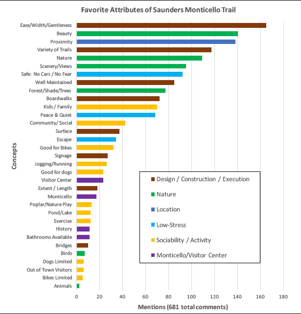
Out of the 1010 survey responses, there were 681 comments of various length. We divided the terms into categories, among which a few key themes emerged. They are summarized, in chart form, above. Here's what they tell us:

Design and Upkeep
The gentle, sloping boardwalks are wildly popular. Users like that they moderate the challenge of climbing a mountain and make the trails accessible to people of all abilities. They like that they’re wide enough to be social, that there are also more rugged options, there is educational signage along the way and they are long enough to merit a trip. The meticulous maintenance is a very significant contributor to the sense of welcome.

Nature
Visitors love the park’s natural beauty.

Proximity to Where they Live and Work
Exposure to nature in a way that is highly welcoming and close to home completes a triangle that explains the park’s success.

No Cars, No Fear, No Stress
The Saunders Trail is a stress-free environment. Some users talked about safety from cars, others about safety from crime. Most users just used the word “safe” and without context it is impossible to know which version of safety they were referring to. They also see the park as a place to get away from daily life. It would be interesting to follow up with research to know how much (and what kind of) contact with humanity is enough for perception of safety from crime. It is clear, however, that park users value the absence of cars, which is interesting given that the trail was built as part of a parkway project.

Kids, Families, Community and Activities
Even though the trail is a place of natural escape, users still value the social connections that happen there, whether they go with friends or meet acquaintances. The park is designed in such a way to promote positive interaction as well as harmony between active and contemplative uses.

Amenities at the David M. Rubenstein Visitor Center and Monticello Itself
It appears that most Saunders Trail users visit the park as a destination independent of Monticello. A small number did indicate appreciation for the connection to the World Heritage Site and the visitor center as a destination and amenity for the trail.

Implications for a Connector Trail
The overwhelming response to the survey indicates very high demand for a connector.

A large percentage of users are from Charlottesville, the others from urban parts of Albemarle, or from out of state. All of these users would benefit from a connection, and the majority have stated they would use it. Many would leave their cars at home, improving community fitness and reducing stress in the parking lot.

Users are interested in a widely connective network that is both kid- and bike-friendly. Accessibility by public transportation and for the elderly and disabled is important. Destinations near all of the corridors are mentioned, with enthusiasm roughly proportional to proximity. There is strong support for an extension to Highland and Morven, which is not one of the routes studied in this report, but is being addressed independently by Highland and Morven.

Amenities like bathrooms, water fountains, and quality signage are desirable. A fractional minority oppose the trail for fear that more users will spoil the Saunders-Monticello Trail experience, but far more indicated they expect an enlarged network would spread users and reduce crowding.

In order for the trail to be well integrated with the Saunders-Monticello Trail it will need to exhibit the following qualities:
  • Users should be fully separated from automobiles.
  • It should be wide enough to comfortably accommodate cyclists and groups of pedestrians.
  • Inclines should be as gentle as possible.
  • It should feel safe for women and the elderly.
  • There should be natural scenery.
  • There needs to be a sustainable maintenance plan.
  • I f cyclists and pedestrians use the same corridor, it needs to be well-managed either through signage, clear rules, or separate facilities.
  • Clear directional and even some interpretive signage would be welcome. 

This is an excerpt from the report Charlottesville to Monticello and Beyond. Read the executive summary and download the full report here.

Tuesday, March 14, 2017

Charlottesville to Monticello and Beyond


Corridors identified for study.


Phase Two of the Monticello Connectivity research project is underway. Five Masters students1 from University of Virginia’s department of Urban and Environmental Planning are studying the feasibility of a pedestrian and bicycle trail to Monticello, James Monroe's Highland and more.
 
The regional Thomas Jefferson Planning District Commission (TJPDC) is sponsoring the study in cooperation with the Thomas Jefferson Foundation as part of its Jefferson Area Bike and Pedestrian Plan. The report to be completed in the Spring of 2017 will examine the Saunders Monticello Trail, possible connection routes, impacts, opportunities and identify resources and case studies.

Learn more


1. Graduate students Maura Harris, Caroline Herre, Peter Krebs, Joel Lehman and Julie Murphy.

Sunday, January 22, 2017

Monticello Connectivity Pre-Assessment:
Executive Summary


Saunders Bridge from Monticello (Aaron Eichorst via instagram)

This is the executive summary of a 50-page pre-assessment report I wrote about reconnecting Charlottesville to Monticello and beyond for pedestrians and cyclists. That document is the result of an independent a study course at the University of Virginia's Masters of Urban and Environmental Planning program. The next phase will be an in-depth practicum in which I will be joined by four other graduate students. We will delve with greater detail into the issues identified in this report. That will be available in the late spring/ early summer. -Peter Krebs

Monticello is an important source of Charlottesville’s history, cultural identity and economic vitality. In combination with the Academical Village at the University of Virginia it is a nearly unmatched resource and very unusual for a town of this size. Monticello is close to the city (its lands are less than a mile from the border) and it is visible from many locations, yet it is difficult to get there without a car. This discontinuity poses problems of equity and unrealized opportunity for Monticello, the city and the region.

Monticello was once easily accessible. There were multiple routes into town with significant travel and exchange in both directions. When Interstate 64 was built (in the 1960’s and 70’s) all of those routes were severed except for one (VA-20) and that was widened for highway speeds without accommodation for bicycles or pedestrians, effectively cutting Monticello off from those who do not have—or choose to use—a car.[1] There is no transit connection, which limits residents and visitors alike.

The Thomas Jefferson Foundation, which owns and operates Monticello and much of the surrounding lands, bridged half the distance in 2000 by opening Saunders Monticello Trail. This winding two-mile pathway is fully ADA accessible (while climbing a mountain!) and its beauty attracts tremendously diverse visitorship. Combined with the adjoining parkland, it is a wildly successful landscape and a destination in its own right yet it is difficult to get there with a vehicle and nearly impossible without one.

Friday, January 6, 2017

Historic Routes to Monticello


1890 Charlottesville Land Company Map, showing several of the lost roads (dashed), Monticello Road and Avenue and Market Street (which still exist) and the path of Interstate 64. (Special Collections Library, University of Virginia via Scholars’ Lab). Click to enlarge.

For most of its history, it was easy to get to Monticello. There were multiple possible routes: through Woolen Mills, Carlton, present-day Monticello Road and present-day Route 20. There was busy commerce along all of these routes and there is enduring evidence—and local memories—of that. The advent of the automobile did not itself cause a disruption. During my earlier work studying Monticello Road, I met long-time residents who used to travel that route and I heard amusing stories of joyrides along the steep and winding road into town.

Construction of Interstate 64 in the 1960’s sliced between Charlottesville and Monticello, obliterating those old routes. The Woolen Mills/Carlton approaches exist in only on maps; Monticello Road is in two disconnected segments (one of which is completely disused) and the Monticello Avenue approach was widened to a four lane divided highway without sidewalk.

There was a flurry of institutional building at that same time, with the opening of Piedmont Virginia Community College (PVCC) in 1973, the original regional visitor center (now PVCC Stultz Center) and the serial re-purposing of the Blue Ridge Hospital (ultimately mothballed in the 90’s). Since then, there has been steady growth south on Route 20 (including several subdivisions and a high school), but pedestrian access has not gotten easier...

This text is extracted from my pre-assessment report, Reconnecting Heritage: Pedestrian and Bicycle Connectivity to Monticello, The executive summary and full text of that report will be available soon.